Introduction. Erosion is an integral part of the sequence of processes by which surface rock bodies become recycled into sediment and eventually into sedimentary rock. It is fundamentally a process of removal, whereby the end-products of weathering are transported by fluid agents from their place of origin to their place of deposition. Erosion acts to reduce the topographic relief of land surfaces to a minimum, that is, to a uniform, planar surface. Topographic irregularities, such as hills and valleys, are therefore in disequilibrium with respect to the agents and forces of erosion. Since the erosional process acts to remove rather than preserve the rock record, a planar discontinuity transcending a body of rock, either parallel or oblique to bedding (while indicating neither displacement nor movement of the adjoining rock masses), is most likely a former erosional surface. That is, it is a surface that has been created by erosive agents, the rocks formerly above which have been broken down and transported elsewhere. These erosional surfaces, which are extremely common in the geologic record, are collectively referred to as unconformities. Bear in mind that the vast majority of the rock material of which the geologic record is comprised consists, in and of itself, as recycled rock material. It is therefore prudent to emphasize the fact that the geologic record, by its very nature, is quite incomplete. The portion of actual, uninterrupted geologic time preserved in a succession of strata, therefore, is probably quite small compared to the time difference between the oldest and youngest identifiable rock strata. In other words, if a layered rock succession is bounded by a 200 million year old rock layer on the bottom and a 100 million year old rock layer on the top, the intervening strata may only preserve a 1 million year total time interval! The record representing the missing 99 million years has either been removed by erosion, or, it was never deposited in the first place. The notion of the general incompleteness of the geologic record is an important one to keep in mind while interpreting Earth history from the rock record.
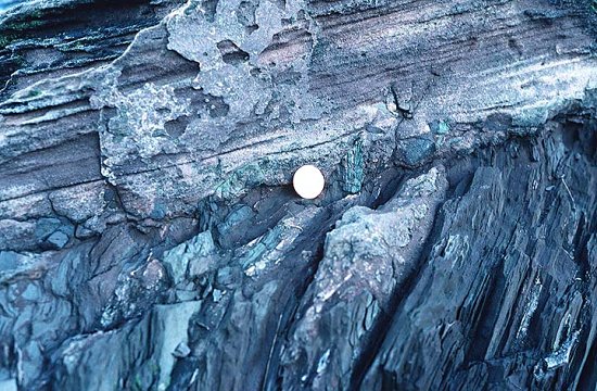
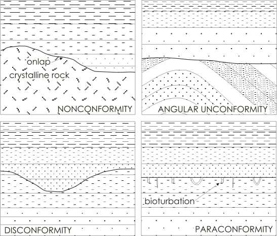
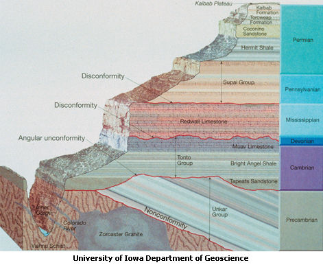
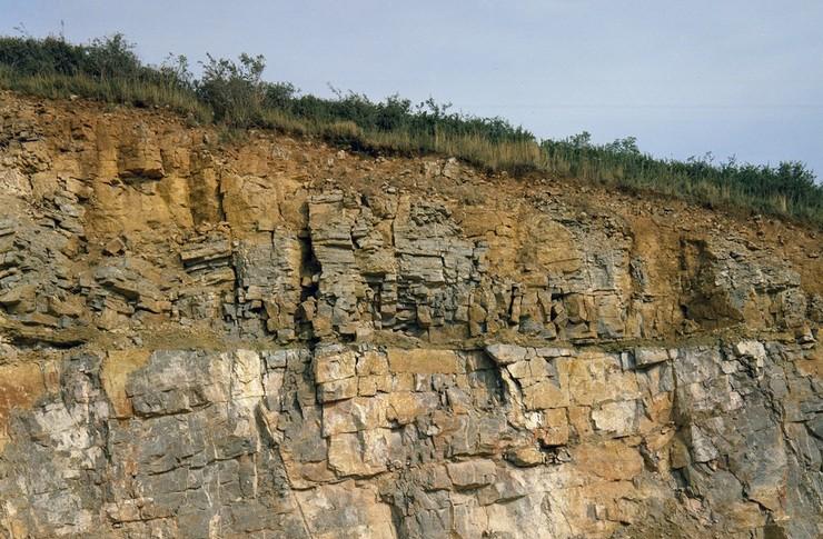
Types of Unconformities. There are three principal types of unconformity, namely, the disconformity, the nonconformity, and the angular unconformity [Fig. 1].
duration [Figs. 3 through 6]. It also suggests a period of deformation and uplift (perhaps orogenesis) which post-dates the deposition of the older strata yet pre-dates the period of erosion which in turn pre-dates the deposition of the younger strata. Angular unconformities are of great value in helping refine the timing and extent of major deformational events in a particular area by providing both an upper and a lower age limit of the event.
Erosional versus Deformational Surfaces. It is also important to distinguish between unconformities and low angle faults since both possess many features in common. Both faults and unconformities are planar surfaces which transcend rock masses. Additionally, both may be laterally consistent over long distances. However, evidence of relative rock displacement within the zone on contact between adjoining rock masses, such as mechanically shattered, scoured, gouged, or polished rock, for example, is indicative of a fault surface and not an erosional surface. Occasionally, unconformities become may even become activated as fault surfaces in later deformational events in response to stress, although this appears to be rare.
Questions.
1. The processes of erosion work to produce a topographic expression that has which appearance?
2. Briefly define the unconformity in terms of its genesis and appearance in the geologic record.
3. Define and distinguish among each of the three basic types of unconformity.
4. Which type of unconformity is the most prevalent in the geologic record yet is the most difficult to identify? Explain.
5. Which type of unconformity exists between a mass of 1 billion year old granite and overlying layers of 50 million year old sandstone? Explain.
6. How can we distinguish between a low angle fault surface and an unconformity?